-
Courses

Courses
Choosing a course is one of the most important decisions you'll ever make! View our courses and see what our students and lecturers have to say about the courses you are interested in at the links below.
-
University Life

University Life
Each year more than 4,000 choose University of Galway as their University of choice. Find out what life at University of Galway is all about here.
-
About University of Galway
About University of Galway
Since 1845, University of Galway has been sharing the highest quality teaching and research with Ireland and the world. Find out what makes our University so special – from our distinguished history to the latest news and campus developments.
-
Colleges & Schools
Colleges & Schools
University of Galway has earned international recognition as a research-led university with a commitment to top quality teaching across a range of key areas of expertise.
-
Research & Innovation

Research & Innovation
University of Galway’s vibrant research community take on some of the most pressing challenges of our times.
-
Business & Industry

Guiding Breakthrough Research at University of Galway
We explore and facilitate commercial opportunities for the research community at University of Galway, as well as facilitating industry partnership.
-
Alumni & Friends

Alumni & Friends
There are 128,000 University of Galway alumni worldwide. Stay connected to your alumni community! Join our social networks and update your details online.
-
Community Engagement
Community Engagement
At University of Galway, we believe that the best learning takes place when you apply what you learn in a real world context. That's why many of our courses include work placements or community projects.


News and Social Media
From Space to Sustainable Seas: EPA-Funded EHIRG Research Pioneers Satellite-Based Oxygen Monitoring in Irish Coastal Waters
Date Released: 11 June 2026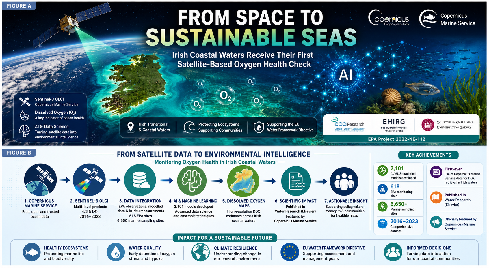
The Eco-HydroInformatics Research Group (EHIRG) at the University of Galway is celebrating a major international research milestone following the publication of a groundbreaking study in Water Research, one of the world's leading journals in environmental and water sciences.
Conducted under the EPA-funded project "An Exploitation of Remote Sensing Copernicus Marine Service (CMS) Products for Monitoring of Transitional and Coastal Waters" (Project No. 2022-NE-112), collaborated with Marine Institute Ireland, Charles Sturt University, Wageningen University & Research and University of Tartu; the study demonstrates, for the first time in Ireland, how freely accessible Copernicus Marine Service satellite products can be used to retrieve dissolved oxygen (DOX) across Irish transitional and coastal waters using advanced machine learning and artificial intelligence approaches.
The significance of the work has been further recognised through its official promotion by the Copernicus Marine Service, which highlighted the study as an example of how open-access ocean data can drive scientific innovation and support environmental decision-making worldwide.
Dr. Agnieszka I. Olbert, Principal Investigator (PI), Civil Engineering, University of Galway
"This research demonstrates how Earth observation technologies can fundamentally transform environmental monitoring. Through the integration of Copernicus Marine Service products, environmental datasets, and advanced analytics, we are creating new opportunities to understand and manage coastal ecosystems more effectively. The project highlights the value of innovation in supporting sustainable marine management and evidence-based environmental policy."
Dissolved oxygen is one of the most important indicators of aquatic ecosystem health. It supports the survival of fish, shellfish, aquatic vegetation, and countless microorganisms that sustain marine food webs. When oxygen concentrations decline, ecosystems can experience severe stress, leading to habitat degradation, biodiversity loss, fish mortality, and the development of hypoxic or "dead zone" conditions. Across Europe and globally, increasing pressures from different sources including Agricultural nutrient runoff, Urbanisation and wastewater discharges, Organic pollution, Climate change and Ocean warming and acidification etc. are accelerating oxygen depletion in coastal waters. These changes present significant challenges for environmental protection, sustainable fisheries, and ecosystem resilience. Monitoring dissolved oxygen at appropriate spatial and temporal scales has traditionally depended on extensive field campaigns and laboratory analyses, requiring substantial financial and logistical resources.
Dr. Md Galal Uddin, Co-Principal Investigator (Co-PI), Civil Engineering, Lead researcher, Eco-HydroInformatics Research Group (EHIRG), University of Galway
"This work represents an important step forward in bridging satellite remote sensing, artificial intelligence, and water quality science. Dissolved oxygen has long been considered one of the most challenging water-quality indicators to retrieve from satellite observations because it is optically inactive. Our research demonstrates that by combining Copernicus Marine Service products with advanced data science techniques, it is possible to generate meaningful insights into oxygen dynamics across coastal waters. This opens exciting possibilities for scalable, cost-effective, and near-real-time environmental monitoring in Ireland and internationally."
The EPA-funded project set out to investigate whether Earth Observation technologies could help overcome these challenges by providing a more scalable and cost-effective approach to monitoring water quality.
The research integrated:
- 🛰️ Sentinel-3 Ocean and Land Colour Instrument (OLCI) products
- 🌊 Copernicus Marine Service Level-3 and Level-4 datasets
- 📈 EPA monitoring data from Irish transitional and coastal waters
- 🤖 Advanced machine learning and artificial intelligence techniques
- 📊 Environmental data science and uncertainty analysis
The study developed and evaluated an unprecedented 2,101 machine learning, AI, ensemble, statistical, and equation-based models to retrieve dissolved oxygen concentrations from multi-level satellite products. The work represents one of the most comprehensive investigations globally into retrieving an optically inactive water-quality parameter from satellite observations.
Unlike chlorophyll-a or turbidity, dissolved oxygen cannot be directly observed by satellite sensors. Successfully estimating it from remotely sensed information therefore represents a significant scientific challenge and a major advancement in environmental monitoring research.
Abdul Majed Sajib, Doctoral Researcher and Lead Author, Civil Engineering, University of Galway
"The project provided a unique opportunity to explore the limits and capabilities of modern machine learning and Earth observation technologies. By developing and evaluating more than two thousand models, we were able to investigate not only prediction accuracy but also model reliability, transferability, uncertainty, and robustness. The findings contribute important new knowledge to the field of remote sensing-based water quality monitoring and establish a foundation for future technological development."
The findings demonstrate the growing potential of combining Earth observation, environmental monitoring, artificial intelligence, and data science to support next-generation water quality assessment systems.
The research provides valuable insights for:
- Water Framework Directive implementation
- Coastal and marine ecosystem management
- Environmental Protection Agency monitoring programmes
- Climate adaptation and resilience planning
- Sustainable Blue Economy initiatives
- Future digital ocean observation systems
Importantly, the study highlights how freely available Copernicus Marine Service products can help expand monitoring coverage while reducing operational costs, creating new opportunities for national and international environmental agencies.
The impact of the research extends well beyond Ireland.
The Copernicus Marine Service, funded by the European Commission and implemented by Mercator Ocean International, officially showcased the study on its international communication platforms under the campaign:
#CopernicusMarine | #OceanData | #DataInAction
The feature recognises the study as a real-world demonstration of how trusted ocean data can be transformed into actionable environmental intelligence, supporting both scientific advancement and evidence-based policymaking. This international recognition reflects the relevance of the research to the wider European marine monitoring community and reinforces the growing importance of Earth Observation technologies in addressing global environmental challenges.
The dissolved oxygen study forms part of a broader EPA-funded research programme aimed at exploring the potential of Copernicus Marine Service products for monitoring Irish transitional and coastal waters. The project has generated a substantial body of research investigating how Earth Observation data can support the monitoring of multiple water-quality indicators, environmental pressures, and ecosystem conditions across Ireland's marine and transitional environments. By combining satellite observations, environmental monitoring, machine learning, and hydroinformatics, the project contributes directly to Ireland's ambitions for:
- Sustainable coastal management
- Enhanced environmental monitoring
- Digital transformation of environmental services
- Climate resilience
- Marine ecosystem protection
- Evidence-based policy development
As environmental pressures continue to intensify globally, research such as this demonstrates how innovative science can help build more efficient, scalable, and sustainable approaches to monitoring and protecting our coastal waters.
Sajib, A.M., Uddin, M.G., & Olbert, A.I. (2026). A Comprehensive Analysis of Retrieving Optically Inactive Indicators from Multi-Level Remote Sensing Product(s) in Irish Waters Using Data Science Techniques. Water Research, Volume 298, Article 125766. DOI: https://doi.org/10.1016/j.watres.2026.125766